Thursday, January 31, 2013

Days Six and Seven

And so this pretty much describes all of Wednesday and half the day on Thursday.  Good for Paradise Ducks but not very good for us.


Finally, a bit of hope Thursday early afternoon.


Bec, Ken and I headed off to play Arrowtown Golf Club.  It's about 30 minutes north of Queenstown.  Arrowtown is an old gold mining town, set in a pretty valley up in the mountains.  The course was a tad on the funky side, but oh so beautiful!!!


Looking back across the course and up into the mountains.

There will be no charge for any golf lessons.  Bec ready to drive on number 9 with Ken looking on.

Looking back at the number 9 tee box.

We got 13 holes in and then the cold rain started again.  An early dinner, pack up, and get ready to head across the Southern Alps and up the west coast to Greymouth tomorrow.

Monday, January 28, 2013

Milford Sound

ABOUT MILFORD SOUND (Piopiotahi)

The World Heritage Fiordland National Park and the breathtaking Milford Sound are located in the  southwest part of New Zealand’s South Island Milford Sound is a place of inspiring landscape, dramatic rivers and cascading waterfalls. Despite being one of the most accessible fiords, Milford Sound remains quiet and still, bounded by steep cliffs and dense rainforest. Rain or shine, Milford Sound continues to captivate even the most traveled.

At the pinnacle of Milford sound is the magnetizing Mitre Peak - standing a proud 1,692 metres (5500 feet) above sea level it is certainly an impressive sight to behold. The Milford Sound is by far the best known of all of the fiords in New Zealand and the only one that can be accessed by road. It is approximately 16km (9.9 miles) from the head of the fiord to the open sea, which means visitors can comfortably travel the length of the fiord to open ocean and return on one of the many cruise options.


The History of Milford Sound

Maori are believed to have discovered Milford Sound more than 1,000 years ago, returning seasonally to the fiord, collecting the much prized pounamu (greenstone). These treks from the east used traditional pathways across passes such as MacKinnon Pass on the Milford Track. The Maori named the sound Piopiotahi after the thrush-like piopio bird, which is now extinct.

In 1912 John Grono was the first European settler to land in the sound. He named Milford Sound after Milford Haven in Wales, while the Cleddau River which flows into the sound is also named for its Welsh namesake.


Maori Myth & Legend

The Maori name for Milford Sound, Piopiotahi, means "a single piopio", harking back to the legend of Maui trying to win immortality for mankind - when Maui died in the attempt, a piopio was said to have flown here in mourning.

According to Maori Legend, Piopiotahi was carved out by Tu-te-raki-whanoa, an atua (godly figure) who was given the task of shaping the Fiordland coast. Chanting a powerful karakia (prayer), he hacked at the towering rock walls with his toki (adze) called Te Hamo.


Flora & Fauna

The underwater environment in the fiords is one of the most intriguing and unique in the world. This is not only because of the beautiful natural environment and the marine reserves that exist here, but also because of an interesting effect of the high rainfall in the area. As rainfall drains through the lush forests, it becomes stained with tannins until it is the colour of strong tea.

The fiords support the world's biggest population of black coral trees - about seven million colonies, some of them up to 200 years old. They are home also to brachiopods; primitive clam-like animals that have been bypassed by evolution, remaining unchanged in over 300 million years. Bottlenose dolphins, New Zealand fur seals, Fiordland Crested Penguins and little penguins are also resident in the fiords.


Geology

Milford Sound, located at the northern most end of Fiordland National Park on the South Island of New Zealand, is a national icon. In places as much as 400 metres deep, celebrated for its pristine landscapes, and remote and rugged beauty, it is actually a fiord, rather than a sound. A river formed valley subsequently flooded by the sea is called a sound, however, Milford Sound was formed by the erosive effects of a glacier and is more correctly a fiord.

Named after its resemblance to a bishop’s mitre (head-dress), Mitre Peak is a prominent peak on the south shore of Milford Sound. Rising 1692 metres, seemingly sheer above the Sound, the summit actually consists of five closely grouped individual peaks.


The Climate

With a mean annual rainfall of 6,813 mm (268 inches) on 182 days a year, a high level even for the West Coast, Milford Sound is known as the wettest inhabited place in New Zealand and one of the wettest in the world. Rainfall can reach 250 mm (10 inches) during a span of 24 hours. The rainfall creates dozens of temporary waterfalls (as well as a number of major, more permanent ones) cascading down the cliff faces, some reaching a thousand metres in length. Smaller falls from such heights may never reach the bottom of the sound, drifting away in the wind.

Accumulated rainwater can at times cause portions of the rain forest to lose their grip on the sheer cliff faces, resulting in tree avalanches into the sound. The regrowth of the rain forest after these avalanches can be seen in several locations along the sound.


 With Mitre Peak in the background, our tour boat approaches the dock to pick us up.


Although one of the most visited sites in New Zealand, the facilities are surprisingly small.


When Becky and I went to the Grand Canyon several years ago, we took tons of pictures only to return home and find out they all looked pretty much the same.  This may be another of those situations.  But we are going to put up a bunch.

Bowen Falls


Stirling Falls.  We'll come back.

Approaching the end of the Fiord and entering the Tasman Sea.

Looking back into the Fiord.

Looking back from the sea, you can see why many explorers passed on by not realizing the Fiord even existed.

Yes this is the two hearty adventurers with Dale Point in the background.

The legend is that women touched by the spray of Stirling Falls will wake in the morning looking 10 years younger.  Never one to challenge legend, I made sure I tagged along.  Just in case!


Seal Point

Fairy Falls and Bridal Veil Falls.

 Mount Kimberly (Lion Mountain)


And so we bid farewell to Mitre Peak and Milford Sound.  We arrived back in Queenstown at about 8:15 PM.


Sunday, January 27, 2013

Tuesday, Day 5

Because of the continuing threat of inclement weather, we decided to move our day trip to Milford Sound from Wednesday to today.  When we awoke we had quite a surprise waiting for us.  Yes that is snow on the mountain peaks above Queenstown.  We were told that this is highly unusual for this time of year.


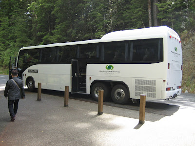
We decided that since all six of us cannot fit in the same car, that rather than drive both cars to the Sound, we would take a charter tour bus.  We are so glad we did.  The extra color commentary provided was well worth the slight difference it would have cost us to drive, and we were not faced with the drive home after a long day.  So at 7:25 AM we loaded onto our coach and are off.


By road, Milford Sound is 307 km from Queenstown(about four hours drive), with most of the tour buses to the Sound departing from Queenstown. Some tourists also arrive from the smaller tourism centre of Te Anau, 121 km away. There are also scenic flights by light aircraft and helicopter tours to and from Milford Sound Airport. The drive to Milford Sound itself passes through unspoiled mountain landscapes before entering the 1.2 km (.75 miles) Homer Tunnel which emerges into rain-forest-carpeted canyons that descend to the sound. The winding mountain road, while of high standards, is very prone to avalanches and closures during the winter half of the year.  The past few days were particularly wet, so mudslides, slips as they call them here, were very much a factor.  In fact only two hours after we cleared the tunnel on the way home, the road was closed and did not reopen for several days.  If I didn't mention it before, this is the ONLY road in or out.

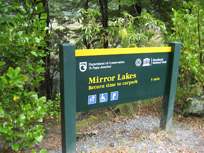
One of our first stops on the way was Mirror Lake.  We thought it was funny how they posted the sign as a mirror image so you could read it in the crystal clear water of the lake.


This beautiful field of Lupens was in full flower.  Lupens are a non-native plant brought to New Zealand by settlers as flowers for their gardens.  They escaped into the wild and proliferated to the extent they are now considered a nuisance weed.  Close by here we stopped to fill our water bottles from a glacier fed stream.  Amazing how pure water tastes.

The scenery is so spectacular along the road.


Now we meet one of the more mischievous characters around.  The Kea, or Mountain Parrot.  This one was posing and showing off for everyone on the bus.  What a ham!


We stopped to await our turn at going through the Homer Tunnel.  The cycle take 15 minutes or so.  This tunnel, as well as the road, was built by people who worked for what we would call the WPA during the depression.  They and their families lived out here in this wilderness for years.  Talk about hearty souls!


Yes, this is a one lane curved tunnel, think driving through a large culvert.  The tunnel was built basically by hand, no large machinery was ever used.  If you don't stay centered, it will conveniently grind part of the roof off of your vehicle.

Because of all of the recent rain, everywhere you looked the cliffs were covered with these enormously long waterfalls.


Today we got a rare glimpse of Mt. Tutoko.  Apparently she is normally shrouded in clouds.


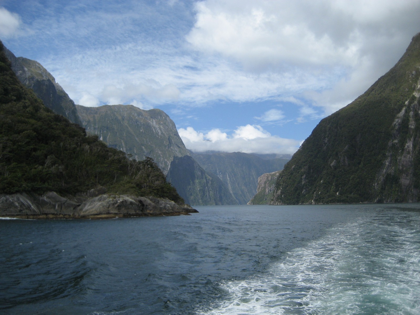
Finally, four hours after leaving Queenstown, we arrived.  With Mitre Peak in the background, we prepare for our boat tour of the Milford Sound.  Grammy and the two grandkids are ready to go!


I'm going to break this now and pick up with the boat tour on a second post.


Day 4

This will be a very short post just to maintain continuity.  The weather began to deteriorate Monday morning and the forecasts are even more ominous.  Although the weather was threatening, Bec and I decided we would play Queenstown Golf Club.  As I said the weather was getting worse, and the winds began to sweep north across Lake Wakapitu.  By the time we finished, the winds were howling at near 70 KPH or 40-50 MPH.  One thing we are learning in New Zealand is to play in the wind.  The course itself was only mediocre and we would not go back.  We forgot the camera, but I was able to find this picture on the internet to give you some perspective.  No real way to escape the wind as you can see.


We were originally going to Milford Sound on Wednesday, but with the weather worsening, and the road there a perilous journey in and of itself, we will go tomorrow.

Friday, January 25, 2013

Day 3

So today we leave the Canterbury Plains behind and head up through the mountains and down to Queenstown.  We are taking Route 79 over to pick up Route 8 then heading up to the Southern Lakes Region.  Some of the most spectacular scenery in all of New Zealand is located here.  This area will also provided us with our first real glimpses of the Southern Alps.   We come up over a small rise and there they are, The Southern Alps.


We continue on to lake Tekapo.  The aqua blue color of the lake is caused by the glacier runoff that feeds the lake.


We were taken with how the clouds appeared to be coming over some hidden spillway high up in the mountains.


Heading on south and west we pass Lake Pukaki with our first look at Mt. Cook, the highest mountain in New Zealand reaching 3,754 metres (12,316 ft). 


From here we continue into the Otago region.  Some of you may recognize this area for its many fine vineyards featuring award winning Pinot Noir, Riesling and Pinot Gris varieties .  This is also the home district to Queenstown.  The scenery is mostly rugged mountains and fast moving rivers and streams.


New Zealand has had its share of troubles with non-native species of plants and animals.  As you can see here a project is underway in Central Otago  to eradicate some very invasive trees and restore the landscape to its original condition.  Other unwanted immigrants include rats, possums, and goats, all which were introduced by outside influences and whose populations have exploded because there are no natural predators to keep then in check.

Finally after a long day, we arrive at our villa overlooking lake Wakatipu with The Remarkables mountain range in the background.

Tomorrow we intend to play golf (the Queenstowns Golf Club is off Hal's right shoulder across the lake) and then on Tuesday we will head to Milford Sound.  So for today,
Haere rā, goodbye in Maori.


Tuesday, January 22, 2013

Day 2.5

As we continue on down the east coast towards our lodging in Ashburton, the road takes us along the coast to the Kaikoura Peninsula. When I say along the coast, I mean right on the coast.  It is amazing to us how isolated and uninhabited much of the coastlines in this country are.

One of the things you have to enjoy about New Zealand is the Kiwi sense of humor.  I would submit that many of the weather folks in the US would be well served by adopting a similar weather prognostication system.


As we approach Kaikoura, we begin to see many of the New Zealand fur seal colonies that are so prevalent around the South Island.  In the late 1800's and early 1900's they were hunted to near extinction, as the European fashionistas clamored for their fur as hats and other garb.  Thankfully, they have come back strong and healthy.


The remainder of the day was spent crossing the Canterbury Plains.  It is a major agricultural area, think Kansas, that is very flat and reminds one of the Great Plains of the US.  Off to the west, their are vistas of the distant mountains.  Other than that, can you say B-O-R-I-N-G!

We'll set off tomorrow up through the mountains and into Queenstown.